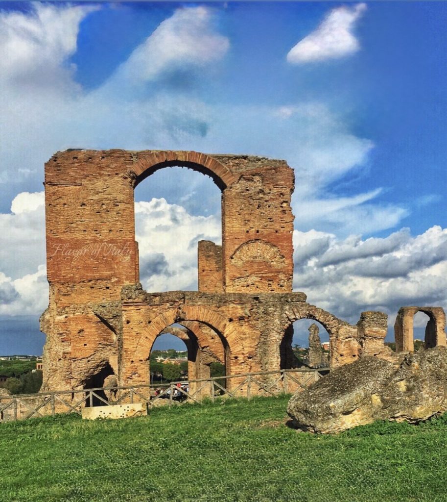
This week on the Flavor of Italy podcast, I stepped slightly outside my usual culinary comfort zone—and discovered that I hadn’t really left it at all. Sitting among the ruins near the Terme di Caracalla, with ancient stones underfoot and Roman roads radiating outward beneath us, I spoke with Tom Brughmans, an archaeologist whose work is reshaping how we understand movement, connection, food, and daily life in the ancient Roman world.
Tom is the director of an ambitious international research project that has produced the first spatially detailed digital atlas of the Roman road system. Not just the famous roads, and not just Italy, but the entire Roman Empire—stretching across Europe, North Africa, and the Middle East. These are the roads people actually used, reconstructed through years of careful scholarship and made visible in a way that has never existed before.
Why the Via Appia Misleads Us
If you close your eyes and picture a Roman road, chances are you’re imagining the Via Appia. Long, straight, paved in stone, flanked by cypress trees and monumental tombs, it feels almost cinematic. It is also largely responsible for one of the biggest misunderstandings about Roman infrastructure.
Roman roads were not built to show off. They were built to work. They followed geography, choosing the path of least resistance, bending when necessary, and changing according to the land they crossed. The Via Appia is exceptional, not typical—and its fame has distorted our mental picture of the entire system.
A "Google Maps" for the Ancient World
Tom and his team of roughly twenty researchers from universities across Europe spent five years assembling every possible source of evidence for Roman roads. They drew from archaeological publications, ancient travel texts such as the Antonine Itineraries, thousands of Roman milestones, historical maps, and modern as well as archival satellite imagery.
Have a question or want to leave your own tips and recommendations? Click here to leave a comment:
Leave a CommentThe result is an online platform that functions much like Google Maps for antiquity. At itiner-e.org, anyone can explore where Roman roads likely ran, see how certain or uncertain those reconstructions are, and understand how places across the empire were connected over land.
Just as importantly, this atlas is not finished. It is designed to grow. Scholars will be able to suggest corrections, submit alternative reconstructions, and contribute new findings as archaeological work continues. Knowledge, like roads, is meant to connect and evolve.

Why Roman Roads Matter for Food
As our conversation unfolded, it became clear that Roman roads are not an abstract academic topic. They are central to one of my favorite questions: how Rome fed itself.
At its height, the city of Rome had a population of roughly one million people. The surrounding countryside was fertile, but it could not support a population of that size. Survival depended on a vast, integrated transport system that moved food across the empire.
Grain came from Egypt. Olive oil arrived from southern Spain. Wine flowed in from North Africa. These goods traveled by ship across the Mediterranean, but once they reached ports, roads took over. The final miles mattered enormously.
One of the most striking pieces of evidence for this system still exists today in Rome’s Testaccio neighborhood. Monte Testaccio is an artificial hill created by the Romans themselves, formed from millions of broken amphorae that once held Spanish olive oil. Over centuries, the containers were emptied, cleaned, smashed, and stacked so systematically that they created an entire hill. It is a monument not to empire, but to logistics.

Movement, Disease, and Migration
Roman roads shaped far more than trade. They structured how people lived, worked, traveled, and died.
They enabled daily movement between farms, villas, and towns. They carried soldiers, merchants, and messengers. They facilitated large-scale migrations that reshaped Europe at the end of the Western Roman Empire. They even played a role in the spread of infectious diseases, which moved as people moved.
To understand pandemics, migration, or political collapse in the ancient world, you have to understand mobility. And to understand mobility, you have to know where the roads were.
For the first time, Tom’s project makes it possible to study these questions at a continental scale, grounded in data rather than assumption.

Watch this video to learn more about Roman Roads. For Italy cultural insights, travels tips, recipes and more, subscribe to my YouTube channel by clicking here
Rome as a Living City
We also talked about why Rome feels so different from places like Pompeii. Pompeii is a moment frozen in time. Rome is something else entirely.
Rome is layered like an onion. Ancient structures were reused as medieval quarries. Roman walls became Renaissance foundations. The city never stopped being inhabited, never stopped changing, never stopped building on itself.
Everywhere you walk, you are moving through time rather than looking at it from a distance. That continuity makes Rome endlessly fascinating, not just archaeologically, but emotionally.
Ostia and the Machinery of Supply
During his visit to Rome, Tom planned to spend time at Ostia, the ancient port city that served as Rome’s gateway to the wider world. Ostia is extraordinary precisely because it was not just another Roman town. It was the engine room of the capital.
All the food, goods, and materials needed to sustain Rome passed through its streets and warehouses. When one harbor proved insufficient, the Romans built another under Emperor Trajan—an enormous octagonal basin surrounded by warehouses and connected by canals and riverboats to the Tiber.

There was so much traffic on the river that parts of it functioned like a two-way system, complete with signals regulating movement upstream and downstream. This was infrastructure on an imperial scale, and it worked.
Why This Project Matters
What stayed with me after this conversation is that the roads themselves are not the end of the story. They are a means to understanding how people lived, worked, ate, traveled, and survived two thousand years ago.
We recorded this episode at a spot where three ancient roads once met: the Via Appia, the Via Latina, and the Via Ardeatina. The latter two are older than the Appian Way and look nothing like it. They curve. They adapt. They respond to terrain, volcanic landscapes, and natural obstacles.
Tom Brughmans is an associate professor of classical archaeology at Aarhus University in Denmark, and the Director of the Roman Roads digital atlas project. The atlas is available to anyone at itiner-e.org, and it is well worth exploring. Once you start tracing those lines across continents, it becomes impossible not to imagine the lives that moved along them.
This episode reminded me, once again, that geography shapes history—and infrastructure shapes daily life, including what ends up on the table.

We’ll be continuing this conversation.
For more about Roman Roads
Roman road system | Ancient Engineering, Construction ... - Britannica
Roman Roads Press - Inherit the Humanities
Roads of the Roman Empire
All 187460 Miles of Road That Led to Rome, Mapped
Roads in Roman Britain | English Heritage
Ancient Roman Roads Mapped in Detail from Great Britain to North Africa
Ancient Rome and an Historical Vineyard
Truth and falsehoods about Roman gladiators
Leonardo Da Vinci's Vineyard

Please leave your comment here. Your feedback is important!